- Tehran–Souda distance exceeds 2,450 km
- Multiple airspaces and defense layers lie between
- Greek F-16s deployed to Cyprus on March 2, 2026
- Naval assets mobilized in the Eastern Mediterranean
- Geography and warning time are key deterrents
News and images source, NeaKriti: Μέση Ανατολή: Παγκόσμιος συναγερμός για γενίκευση του πολέμου – Τα γραφήματα της ΚΡΗΤΗ TV δείχνουν γιατί η απόσταση θωρακίζει τη Σούδα
When television stations start pulling up distance maps, it usually means anxiety has entered the room.
During the main bulletin on Kρήτη TV, graphics traced the stretch between Iran and Souda. Not speculation. Not studio theatrics. Just kilometers.
And the numbers matter.
From Tehran to Souda, the distance exceeds 2,450 kilometers. Even from Iran’s western edge, you are still looking at well over 2,300 kilometers of airspace — not empty sky, but one of the most monitored corridors on earth.
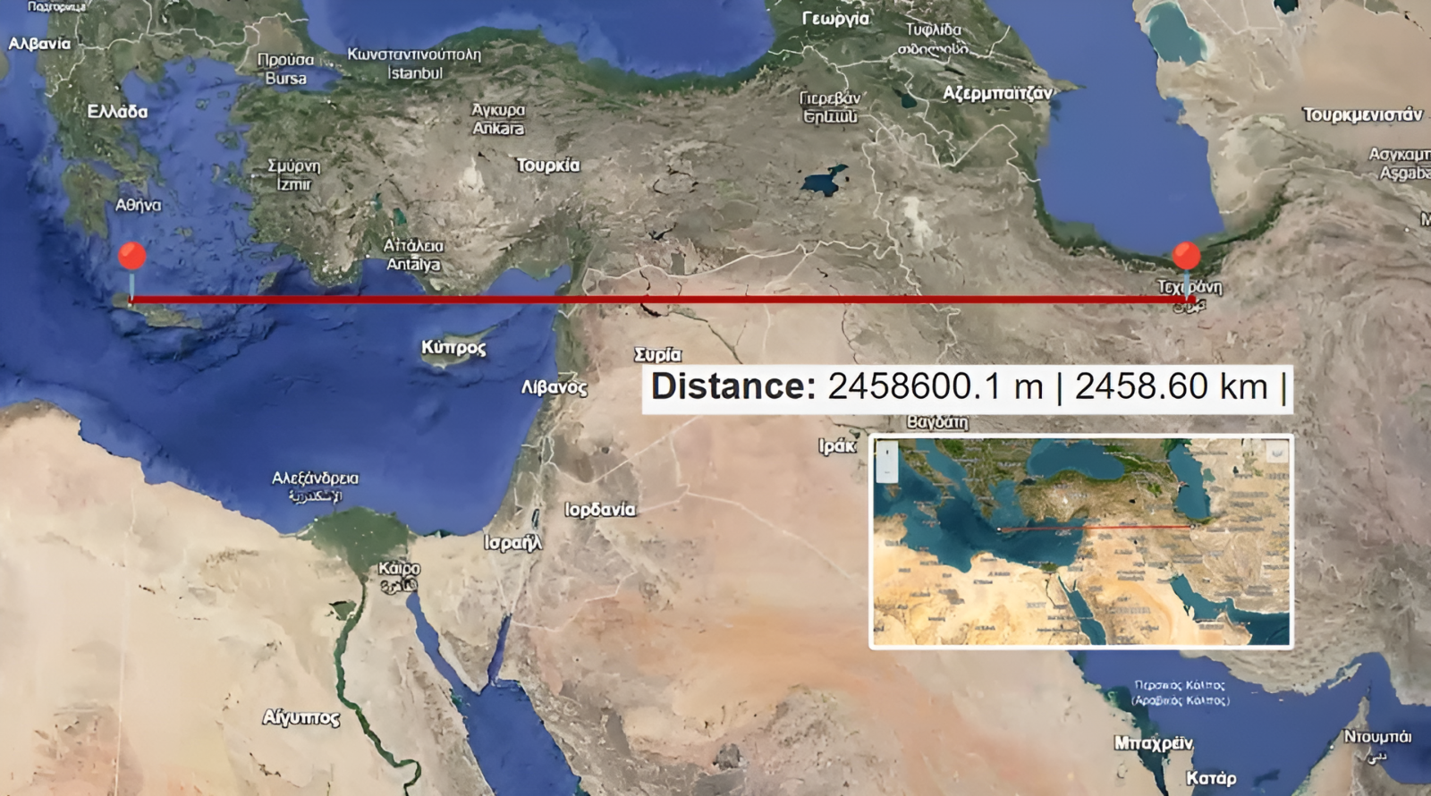
This is not a straight line over calm water. It crosses layered surveillance systems, allied airspaces, and permanent naval patrol zones.
Distance Means Time
In military discussions, time is rarely abstract. Distance creates time. Time creates options. A projectile covering that range would not appear out of nowhere. There would be detection windows, tracking phases, and response procedures. The Eastern Mediterranean is not an unguarded backyard.
Between Iran and Crete stand:
- Israeli air defense networks
- Cypriot monitoring systems
- NATO maritime presence
- Electronic countermeasure capabilities
Long-range drone flights over open Mediterranean waters are not simple endurance exercises. They are vulnerable to disruption. Jamming is not science fiction. It is standard equipment that does not eliminate risk, but it reframes it.
Visible Movements, Measured Tone
On Monday, March 2, 2026, four Greek F-16s landed in Cyprus as reinforcement. They departed from Souda — two from the 340 Squadron “Alepou” and two from the 340 Squadron “Asteri.”
Naval movements followed familiar logic: FDI frigate Kimon. MEKO-type frigate Psara, equipped with the anti-drone system “Kentavros.”
This is what deterrence looks like in practice—aircraft reposition. Ships adjust. Command centers talk more than usual. Prime Minister Kyriakos Mitsotakis has scheduled meetings with political leaders. Diplomatic channels remain active. That is not escalation. That is governance.
Souda’s Geography Is an Asset
Souda Bay is not an exposed coastline. It sits inside a natural harbor protected by mountainous terrain. It is supported by the 115 Combat Wing and shielded by air defense systems, including S-300 and Patriot units stationed in Crete.
Additional systems, such as “Kentavros” and “Toxotis,” strengthen the defensive grid. Nothing in security is absolute. But layered protection changes calculations. And calculations are what matter.
So What Do We Do?
We do not turn maps into panic.
We follow official civil protection channels. We avoid forwarding dramatic voice notes. We remember that social media thrives on fear, not accuracy.
For residents of Crete:
- Monitor official announcements
- Keep 112 saved on your phone
- Ignore anonymous “sources.”
- Trust structured information over viral posts
There are currently no civilian directives beyond awareness.
And awareness is different from alarm. Crete’s location in the Eastern Mediterranean has always been strategic. That has not changed this week. What has changed is the temperature of the headlines. The maps presented on television were not meant to frighten. They were meant to scale the conversation. More than 2,400 kilometers is not “next door.” And in geopolitics, scale is often the difference between tension and threat.