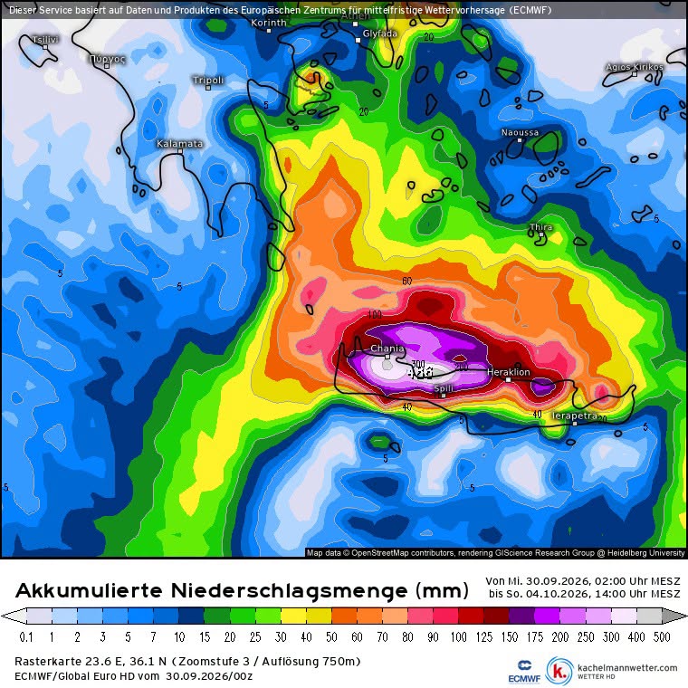
- A low-pressure system settling over the eastern Mediterranean is forecast to unleash severe, torrential rainfall across Crete, particularly targeting the northern slopes of the Cretan mountains.
- According to the European ECMWF model, rainfall totals could exceed 450 liters per square meter by Sunday noon, while the German model similarly projects over 400 liters per square meter.
- Given these extreme precipitation projections, severe flooding is anticipated across the region, prompting urgent warnings for residents and holidaymakers to closely monitor conditions.
Crete is facing a potentially very wet few days as a low-pressure system settles over the eastern Mediterranean, with European weather models indicating exceptionally high rainfall totals across parts of the island.
The latest ECMWF forecast shown on the accompanying map puts some of the heaviest accumulations in the mountain areas of northern Crete, with locally more than 450 mm of rain possible by Sunday. The German weather model is also indicating totals exceeding 400 mm in some areas.
The forecast pattern is particularly concerning for Crete’s northern mountain slopes, where moist air pushed against the terrain can produce prolonged and intense rainfall.
The ECMWF map shows the highest projected accumulations concentrated across central and western parts of the island, with exceptionally high totals around the mountain ranges between Chania, Rethymno and Heraklion.
These figures represent accumulated rainfall the model predicts over the forecast period. They should not be interpreted as a guarantee that every location will receive the amount shown on the map. Forecast totals can change as the system develops.
Still, rainfall totals of this magnitude could produce serious flooding, particularly in areas where heavy rain falls over a short period.
Flooding Is the Main Concern
Crete’s steep terrain means that very heavy rainfall can quickly turn mountain streams, roads and drainage channels into dangerous waterways.
Low-lying roads and areas near streams are particularly vulnerable, while rockfalls and landslides can also become a problem on mountain roads after prolonged rainfall.
Residents should watch official warnings as the weather system approaches and avoid crossing flooded roads or flowing water.
A Warning for Travelers
For travelers currently in Crete or arriving over the next few days, the weather is worth watching.
This is not a forecast suggesting that the whole island will simply be washed out from one end to the other. Rainfall will vary considerably from one part of Crete to another, and conditions can change quickly in mountainous areas.
Visitors planning drives through the mountains, hiking excursions or trips into rural areas should check the latest weather and road information before setting out. If authorities issue restrictions or warnings for particular roads or villages, those instructions should take priority over travel plans.
Crete can handle ordinary autumn rain. Several hundred millimeters in a short period is a very different proposition.
The ECMWF and other models will continue updating as the low-pressure system develops. Each new forecast run will clarify the exact location and timing of the heaviest rainfall.
For residents and visitors, the sensible approach is simple: keep checking the official weather and Civil Protection warnings, especially if you are heading into the mountains or driving through areas already vulnerable to flooding.